SpinningWing > Helicopters > Helicopter Components > Avionics
|
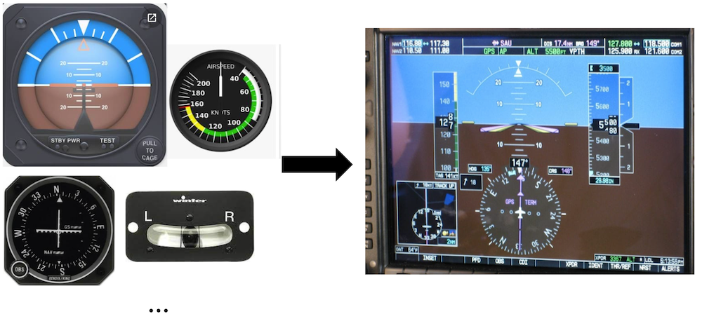
By Jim Davis 2021-03-12 (Last Updated October 3, 2023) AvionicsThe term avionics is a combination of aviation and electronics. It refers to the electronic systems onboard an aircraft. These systems may be used for communication, navigation, monitoring and control. For military helicopters, threat detection and weapon firing capabilities may also be included. A familiar example of helicopter avionics is a GPS system that determines the position of the helicopter and displays it on a moving map. Other avionic systems are described below. CommunicationsVarious communication systems may be onboard a helicopter. First, due to the high levels of aircraft noise, an intercom is normally installed to facilitate communication between occupants. Each person typically wears a headset with speakers and a microphone. Very high frequency (VHF) radio communication is used for communication between two different aircraft, or for communication with air traffic control. High frequency (HF) radio and/or satellite communication systems may also be installed on helicopters for longer distance communication, beyond line of sight. In some cases, normally military helicopters, communication systems may be encrypted. MonitoringModern helicopters include so-called glass cockpits with multifunction displays. These displays (e.g. LCD screens) show information from a variety of subsystems. One display can show information that was traditionally scattered across multiple gauges. For example, a typical display can show a slip ball, attitude indications, airspeed information, radar altitude, rotor speed, torque, and more. These displays can change during flight to highlight the most important values. For example, if the fuel tanks are low a “low fuel” warning may become prominent on the screen. If the helicopter nears a torque limit, then the torque value may be highlighted. Such behavior improves situational awareness for a pilot.
These displays are sometimes customizable, so that a pilot can set up the screen layout to fit his/her style or current mission. NavigationA helicopter may include various devices to help a pilot navigate. Examples include GPS, INS, and radio-based navigation. Modern helicopters will compute their location from these instruments and display it on a map with other locations of interest. Helicopters equipped with autopilot systems may use this information to automatically maneuver the aircraft towards a target location. Several radio-based navigation methods have been used throughout history. High frequency radio waves are generally sent/received between a ground station and a helicopter. In some applications (e.g. VOR and TACAN) the radio signal from the ground station varies by direction, enabling the receiving aircraft to determine the direction from itself to the ground station / airport. Distance between a helicopter and ground station can also be estimated with radio waves. For example, DME and TACAN systems send a signal from the helicopter to a ground station. Upon receiving this signal, the ground station sends a reply to the helicopter. Helicopter avionics estimate the distance to the ground station using the time it takes to receive the reply. These signals may also encode the ID of the ground station. Flight control systemMost large, modern helicopters include a stability augmentation system (SAS). Such systems include gyros that detect pitch, roll or yaw disturbances and add a correction to the pilot’s control positions to counter them. Furthermore, some SASs enhance intended attitude changes when the pilot moves the controls. The SAS may be turned on or off, typically via a PBA, by the pilot. Some helicopters have an autopilot system. These systems typically have an attitude hold mode (ATT) and possibly hover hold, altitude hold, speed hold, etc.... As the name implies, attitude hold maintains pitch, roll and yaw allowing a pilot to completely release the controls. This differs from the SAS which only arrests the rate of attitude change, but does not return the attitude to a reference value. The higher-level modes typically have options: speed hold may use ground speed or airspeed, altitude hold may be based on pressure altitude or radar altitude (height above ground). A flight director system may also be onboard, which computes steering commands for navigation. An autopilot system may optionally be coupled to the flight director to automatically maneuver the aircraft to target locations. Collision-avoidance systemsMany large helicopters have traffic alert and collision avoidance systems (TCAS). These systems use transponders (devices onboard all aircraft to receive and respond to radio signals) to locate other aircraft and warn the pilot. Other systems may be included to warn the pilot of terrain collisions. Ground-proximity warning systems use radar altitude to detect when the aircraft is approaching the ground. More sophisticated terrain awareness systems use digital maps of terrain height in conjunction with navigation equipment to foresee potential terrain collisions. Health monitoring systemsData from various sensors are increasingly used in health and usage and monitoring systems (HUMS). The goal of HUMS is to increase safety and affordability by repairing / replacing parts at more appropriate times. Historically parts were repaired / replaced according to simple schedules. For example, replace the gearbox after five years of operation. However, more sophisticated analysis may reveal that a gearbox was lightly used and can actually survive ten years safely. Alternatively, the analysis may inicate a gearbox had an unusually rough life and should be replaced in 3 years. HUMS analyze data from many sensors and subsystems to provide these improved maintenance schedules. HUMS analysis may be done at a ground station, in which case the helicopter has a method (sometimes a removable memory card) to export data. Wikipedia has an article about HUMS with much more information. Putting it togetherTo achieve the functionality described above, several sensors, computers and software applications must be installed on a helicopter. Some of these systems must communicate and many outputs must be routed to displays in the cockpit. The systems that achieve this are referred to as the aircraft network. For military helicopters, the MIL-STD-1553 standard is often used for this communication. |